• Can't post after logging to the forum for the first time... Try Again - If you can't post in the forum, sign out of both the membership site and the forum and log in again. Make sure your COG membership is active and your browser allow cookies. If you still can't post, contact the COG IT guy at IT@Concours.org.
  • IF YOU GET 404 ERROR: This may be due to using a link in a post from prior to the web migration. Content was brought over from the old forum as is, but the links may be in error. If the link contains "cog-online.org" it is an old link and will not work.

Lost in Colorado....Thanks GPS!

tnrider

Moped
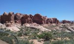
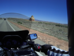
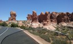
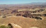
From Cookeville, TN to Gallup, NM last Wednesday and Thursday on my 2001 C-10. Monsoon hit me in Little Rock. Friday rode up to Moab, UT. Beautiful scenery. I think the whole 4 corners area could be a National Park. Then GPS sent me towards Denver on I-70 East. I thought, why not try a new route going home? Motoring along at 75 mph (speed limit was 75) and a sign said that I-70 East was closed up ahead due to fires!!!! Got off and road to Montrose, Colorado. I could have smashed my GPS as it kept saying to get back on I-70 East.

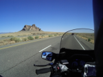
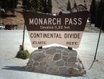
So next day I used my smart phone instead which took me into the mountains and then kept messing up!!!! Reverted back to GPS. Freezing temps, mountain roads with no guardrails, few gas stations, and I left my cap on my camera while taking pictures!!!  Went over the pass at Monarch mountain (elevation around 11,000 feet - the sign photo is from stock not my picture). My C-10 carbs did okay although I had to stir the gearbox to climb.  Great Trip!!!!
 

Attachments

  • 20180525_131010_resized.jpg
    20180525_131010_resized.jpg
    84.8 KB · Views: 109
  • 20180525_132409_resized.jpg
    20180525_132409_resized.jpg
    124 KB · Views: 122
  • 20180525_150500_resized.jpg
    20180525_150500_resized.jpg
    141.9 KB · Views: 120
  • 420px-Monarchsign.jpg
    420px-Monarchsign.jpg
    41.2 KB · Views: 120
Great photos and I hope to ride those same routes some day. As far as the GPS goes, I used to get frustrated the same way. Then I figured out it’s quirks. You didn’t mention what brand, but it it was my Garmin and it wanted to put me back on the highway, that would have been the clue to go to Settings/navigation/avoidances and unselect highways. You can also choose other options while in there and even set some waypoints or towns on the map or “where to” to get you where you want to go. I never trust the GPS to do what I want to do without some assistance. Like employees that work for you, it takes some effort to get them thinking the way you do.  ::) Hope that helps.
 
I came to peace with my GPS by NOT turning on a route, or if I do, I sometimes turn the recalculate OFF or the Volume OFF.

I have a general idea where I'm going which is good enough for me and in keeping with the way I like to travel.

If I leave routing on and follow it blindly, I'll go right through larger towns in hot stop and go, where as if I look ahead, I can skirt around on the fly to keep moving.

I do use the GPS to spot roads near me I might never had noticed, and have seen lot of good roads and things that I would otherwise have missed by doing this.

I also keep the accompanying state map in the tank bag map pocket to keep my bearings.
 
I did have waypoints programmed for my trip and was going to head back to the South toward I-40 but I decided to just hit the Go Home button instead.  Honestly, getting lost in the Rockies made the trip much more interesting (and scary).  I felt a great sense of accomplishment to even take the trip as I attempted to do so 3 times earlier this year. I did the trip last year and missed several sites. But I also remembered the pain and suffering to get there and back. :'( This trip was over 3500 miles in five days (I hate to stand still). I like to ride alone which also increases the risk factor.  :-\

I lowered my C-10 considerably which allowed me to reach the ground better and actually stop to see sites along the road.

The C-10 performed beautifully.  What a trusty steed.  :beerchug:

I wonder what the highest altitude is that someone has ridden a C-10? :motonoises:
 

Attachments

  • 20180525_132405_resized.jpg
    20180525_132405_resized.jpg
    134.9 KB · Views: 98
Nice trip! I remember riding thru Colorado back in September 2003 or 2004 right after I bought the Wing. I found myself on the west side of the divide and had to get back to work in a few days, so I had no choice... I had to go over Monarch Pass right after a snow squall blew thru the area.  Fun times. I made up my mind that I'd need to add heated grips and an outlet for heated gear on that trip. 

enhance


Yeah, it was plenty chilly that day...

enhance


One more...

enhance

 
TnRider, you're building a great trip report - hope you keep going!
Actually sounds like a lot of fun.

 
Send to to Ed Palmer. You may have to look him up in the Officer section of the website :
Ed Palmer, FL Editor@cog-online org

I'll PM you his email.

Thanks and good luck!
 
Thanks. Yeah, I do enjoy these adventures.  They stay with me long after I've returned home. The article I wrote goes into more detail regarding what I went through so I hope it gets published. :motonoises:

The thing is that even outside the parks you see beautiful sites.  The pictures are from a highway north of Gallup, NM on my way to Moab, UT.
 

Attachments

  • 2.png
    2.png
    139.5 KB · Views: 106
  • North of gallup, nm.png
    North of gallup, nm.png
    248.7 KB · Views: 106
Ed is slowly getting more volume of submissions, so just hang on. Maybe he'll get to it. Thanks for sending it in.
Ron
 
TnRider said:
Yeah, he notified me already.  Grateful for all the work everyone does here.  :beerchug:

The next issue is shaping up nicely already thanks to some great submissions like this one.

The Spring issue (a total misnomer given the weather we've been having) should be hitting U.S. mailboxes now.

I've been a little slow the last couple of weeks to due travel for work.
 
Top