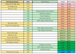
• Can't post after logging to the forum for the first time... Try Again - If you can't post in the forum, sign out of both the membership site and the forum and log in again. Make sure your COG membership is active and your browser allow cookies. If you still can't post, contact the COG IT guy at IT@Concours.org.
  • IF YOU GET 404 ERROR: This may be due to using a link in a post from prior to the web migration. Content was brought over from the old forum as is, but the links may be in error. If the link contains "cog-online.org" it is an old link and will not work.

2022 National Routes

As most of you know by now, the Redux part of the 2022 Rally name Razorback Redux refers to re-doing the 2012 "No Bad Roads Rally". In my attempt to organize the routes I have labeled the 2012 routes Redux as we are "redoing" them. Perhaps I should have called them Original No Bad Road Routes, but now it's too late. If in doubt as to which is which, go by the date. Thanks to Corbin (Butch) Youngblood for creating them then in 2012, and saving them all for us to use now. Below is a link to the descriptions for most of them from 2012. None of the links on that page survived the forum software transfer, only the descriptions remain. Also, I might have misspelled Redux as Redeux in a few too many places. 😟 Please just ignore that and consider the source. :confused:

https://rally.concours.org/national/nationalrally2012/riding

------------------------------------------------------------------------------
The 2022 routes are a varied mix.

There are 4 routes labeled as Xpress routes. Unlike most motorcycle routes these do not emphasize the route itself but rather the destination. These were made for when you get a late start, or it's pouring down rain in the morning and can't ride until afternoon, or whenever time is short for whatever reason and you just want to go somewhere so as not to waste the day sitting around camp or the hotel.

The Branson Show Town Xpress
(Slo-Xpress might be a better name) was made mostly for people not familiar with the area and maybe had heard about Branson, but had never seen it. I noticed that the Branson Loop from 2012 didn't actually go into Branson proper so I just made this Xpress route to go through town and see the main Theater lined streets and attractions. If you ride this route expect slow traffic and perhaps some elderly automobile drivers that should have hung up their driving gloves several years ago. They may get confused occasionally as to which pedal does what, but they all remember where the horn is. 😖 Be careful and watchful. Parking the bike somewhere (be careful, lots of hilly parking lots) and calling a nice air conditioned Uber to take you around town would not be a ridiculous idea. The downtown dime store (Google: Di¢k's 5&10 with a C instead of a ¢ :rolleyes:) is interesting if you like tight spaces and lots o' stuff. Mel's Hard Luck Diner is interesting as well, where the aspiring artists waitstaff sing and their CDs are all available for sale in the gift shop that you go through to pay your bill. (Might I suggest tipping them, but don't buy the CDs?) After eating at Mel's you can step across to Kringles Christmas Shop to buy yourself a souvenir ornament.

The Oark Store Xpress just goes to the historic store and back to the hotel. (note: store closed Tuesday)

The Pig Trail Xpress just goes through the Pig Trail Scenic Byway, stops at a gas station and returns to the Hotel via the same route.

The Cliff House XPress just goes to the Cliff House Restaurant, so named because it sits on a cliff with a very good view. It doesn't go to Cliff's house, Cliff being "Just Cliff" on the forum.
(Note: Restaurant closed Monday and Tuesday; Open 9 AM-3:45 PM Wednesday and Thursday)

Speaking of Cliff, he was nice enough to give us 3 maps, which will be on display at the National, where he highlighted and ranked some of the best roads (in his expert opinion) in Arkansas. I've adapted (as best I was able to, Cliff will be the judge as to how well I did) 4 of the six routes he highlighted for us into BaseCamp routes. I may have gotten the direction of travel that Cliff intended wrong. If so I'm sorry, and as the papers say " I regret the error(s)".

The TriState Lunch Run is a loop through three states with an optional lunch stop In "Kansas" Oklahoma that I recalled as best I could from another rally
(MSTA) that I attended in the area years ago. I enjoyed a lunch there with great service a couple of times, but I'm no food critic so check the online reviews.

The Overlook Loop is a ride going to three of the most scenic high point overlooks in the state. If you like high places and vistas this should be of interest. Originally it went to a couple of additional overlooks on Red Bluff Drive in Petit Jean State Park, which are still there, but the road is all gravel now
(and not in as good a condition as Google Street view makes it look, at least it wasn't in April 2022) and even though I survived it without dropping my C14, I couldn't in good conscience send anybody else up there. The Mount Magazine road inside Magazine mountain State Park is made up of tar snakes but it has a low speed limit (35 mph), still use caution especially if it's a hot sunny day. The Jean Petit Grave-site & Overlook is a pretty good road with a nice paved parking lot which is wide enough at the end to be considered a loop end. The road going up Mount Nebo has several 10 MPH uphill inside turns, as you look through the turn your head will have a considerable tilt upward. If you have any doubts about your riding abilities, this would be the overlook to skip. At the very least have a friend with you to help lift your bike if you drop it in one of these turns. :unsure:

Apologies to the campers for starting all the routes at the hotel....but I'll bet most of you are used to that by now? :censored:
 
Last edited:
Speaking of Cliff, he was nice enough to give us 3 maps, which will be on display at the National, where he highlighted and ranked some of the best roads (in his expert opinion) in Arkansas. I've adapted (as best I was able to, Cliff will be the judge as to how well I did) 4 of the six routes he highlighted for us into BaseCamp routes. I may have gotten the direction of travel that Cliff intended wrong. If so I'm sorry, and as the papers say " I regret the error(s)".

Whatever you did Marty is gonna be good nothing was set in stone & I had no route direction in mind. Since I don't use a GPS & don't know about GPX files or am I computer literate enough to plot computer maps I just randomly highlighted some routes. Only so someone with more smarts than I could connect the dots more precisely & figure the mileage. I just know by looking at the map about what my time frame would be to ride a route. I can't even seem to open the posted routes to view them not that it really matters.
 
Here is a list of National Rally routes sorted by distance. It will be posted at the National, however you may wish to print out your own copy (PDF attached) or take a phone photo to bring with you for in-room/tent/camper route selection planning the night before/morning of ....as the case may be.

index.php
 

Attachments

  • Route list sorted.pdf
    34.3 KB · Views: 85
  • route sort list.jpg
    route sort list.jpg
    209.4 KB · Views: 411
Last edited:
Between all the variable settings on each of our GPS units and the different configurations possible in BaseCamp doing routes can be...

🥴😵‍💫😵🥵🤬🤪

...however...onward through the fog...

I was told that the Pig Trail Xpress can get recalculated to a faster route. I'm not sure how that gets done but I guess if one zoomed over to the interstate south and then went east it could be possible. It may be how BaseCamp is set for speed on different types of Highways. I doubt it would save much time, but whatever....
...accordingly I've added some way points for shaping purposes to that route to prevent (I hope) such an occurrence on your GPS unit. The file
has been uploaded separately to a file named Pig Trail Xpress 1.1.gpx

Also, Butch (forum name Rbentdude) said that when he made the Mt Judea Loop route in 2012 that he had considerable difficulty making BaseCamp (probably MapSource back then) stick to the route he wanted, so he had to put in many way points for shaping purposes...however he said listening to the GPS announcing each one was very undesirable, and he asked me to remove the announcements of same. Even though I didn't want to make any changes to the 2012 routes for historical reasons (🤥 🤫 really so he'd get the blame for mistakes instead of me) I have removed the announcements from those way points and uploaded the route as Mt Judea Loop 1.1.gpx
If you have already downloaded routes you may want to replace the 1.0 versions of each and download the 1.1 versions.
 
Last edited:
Some of us enjoy helping the new guys get involved, and (unofficially) planned a Newbie ride on Tuesday Morning.
(The idea is to show some of the Newbies (ie; First time National Attendee's) around and get you involved in the fun).

The ride will leave ASAP after the scheduled Newbie meeting.
We'll gather, have a ride brief, and go.

Let me know if you're interested??

Details; making them up as we go....
It will be about a 4-6 hour ride {with a lunch stop planned}.
Generally speaking, we're headed south...
Pace; Moderate to Brisk.

Bottom line; (We'll "all" follow Bob)
We'll post a sign up sheet in Registration for those that are interested {??}
Unsure how many can go. Mebbe 10 bikes.
If more sign up, we'll try to figure something out.

Speaking of which; If any of the Not first time attendees want to help out, please contact me and let me know if you could lead a few folks.
We can unofficially do some unofficial planning and send you the Newbie route.

Ride safe, Ted
 
.Speaking of which; If any of the Not first time attendees want to help out, please contact me and let me know if you could lead a few folks.
We can unofficially do some unofficial planning and send you the Newbie route.

Ride safe, Ted

I'm not real crazy about leading, mainly for fear of going to fast or slow with people I don't know. I would be willing to bring up the rear & pick up stragglers or someone missing a turn.
 
Some of us enjoy helping the new guys get involved, and (unofficially) planned a Newbie ride on Tuesday Morning.
(The idea is to show some of the Newbies (ie; First time National Attendee's) around and get you involved in the fun).

The ride will leave ASAP after the scheduled Newbie meeting.
We'll gather, have a ride brief, and go.

Let me know if you're interested??

Details; making them up as we go....
It will be about a 4-6 hour ride {with a lunch stop planned}.
Generally speaking, we're headed south...
Pace; Moderate to Brisk.

Bottom line; (We'll "all" follow Bob)
We'll post a sign up sheet in Registration for those that are interested {??}
Unsure how many can go. Mebbe 10 bikes.
If more sign up, we'll try to figure something out.

Speaking of which; If any of the Not first time attendees want to help out, please contact me and let me know if you could lead a few folks.
We can unofficially do some unofficial planning and send you the Newbie route.

Ride safe, Ted

I'm a newbie to Nationals ( my first ) but not a newbie to COG or R can saw roads.😁 So do I qualify 😏 🤔

Dale
 
Top